About Kefalonia topoguide
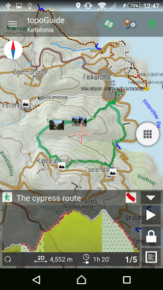
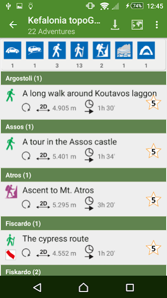
Kefalonia topoguide is a digital field guide for hiking and touring in the Kefalonia Island. It includes routes, descriptions and photos for 23 hiking and mountaineering trails, 3 birdwatching routes, 2 routes for...
Kefalonia topoguide is a digital field guide for hiking and touring in the Kefalonia Island. It includes routes, descriptions and photos for 23 hiking and mountaineering trails, 3 birdwatching routes, 2 routes for butterfly observation, one floristic trail, 2 geological trips, 2 SUV and a road trip, covering the whole Kefalonia Island. Each Adventure has a description, photos and a POIs list.
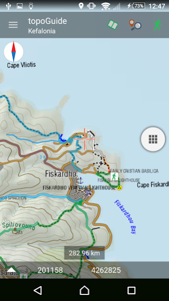
The application offers detailed offline maps and an extensive introduction on geography, geology, the ancient defensive system, the history and the nature of Kefalonia Island. The app offers also a useful list of POIs with a comprehensive search engine.
The trails list includes easy walks, easy and moderate hiking trails and long mountain traverses, of a total length of 183 km.
Geological routes include all major features of the impressive geological environment of Kefalonia.
In the field, the app identifies the nearest adventure, guides you to it and then along it by displaying messages and warnings on every junction or other important location. On each Point of Interest, photos and texts are displayed on the map. If the hiker gets off-trail, the app indicates the shorter way to get back safely.
The cartographic company AnaDigit, creator of the application, has issued hundreds hiking maps for Greece (eg. maps of Crete, Zagori, Sifnos, Naxos and other Aegean islands). To build the application and ensuring data accuracy, all tracks and cartographic information have been recorded again during 2015.
Previous Versions
Here you can find the changelog of Kefalonia topoguide since it was posted on our website on 2016-10-07 09:21:37.
The latest version is 4.3 and it was updated on 2024-04-19 22:10:18. See below the changes in each version.
Kefalonia topoguide version 4.3
Updated At: 2021-05-13
Changes: Thank you for using our app!
This version fixes small bugs.
Kefalonia topoguide version 4.1
Updated At: 2020-05-01
Changes: Map:
. Adds labels to user points
. Easier assignement of a waypoint as target
. Track recording resume track after app restart
. Easier track edit by tapping on the map
Adventures:
. You can now mark an adventure as "Done"
. New filter for "Done" adventures with display of total length and ascent/descent
Several other improvements & bug fixes. Android 10 optimizations.
Kefalonia topoguide version 40
Updated At: 2020-01-31
Changes: Adaptation of several function to Android 10 requirements
Interface changes
Labels on the wyapoints
Continue recording on the same track after a crash
Convenient assign of a waypoint as a destination target
Easy edit of a track by tapping on the map
Several other changes
Kefalonia topoguide version 3.9
Updated At: 2018-11-16
Changes: New data in the guide book
Kefalonia topoguide version 1.8
Updated At: 2016-09-09
Changes: Version 1.8 adds:,Many improvements and bug fixes
Disclaimer
Official Google Play Link
We do not host Kefalonia topoguide on our servers. We did not scan it for viruses, adware, spyware or other type of malware. This app is hosted by Google and passed their terms and conditions to be listed there. We recommend caution when installing it.
The Google Play link for Kefalonia topoguide is provided to you by apps112.com without any warranties, representations or guarantees of any kind, so access it at your own risk.
If you have questions regarding this particular app contact the publisher directly. For questions about the functionalities of apps112.com contact us.